
Wadi Rum Map – Your Guide to the Desert
Discover the desert’s iconic sites and trails with our interactive Wadi Rum map.
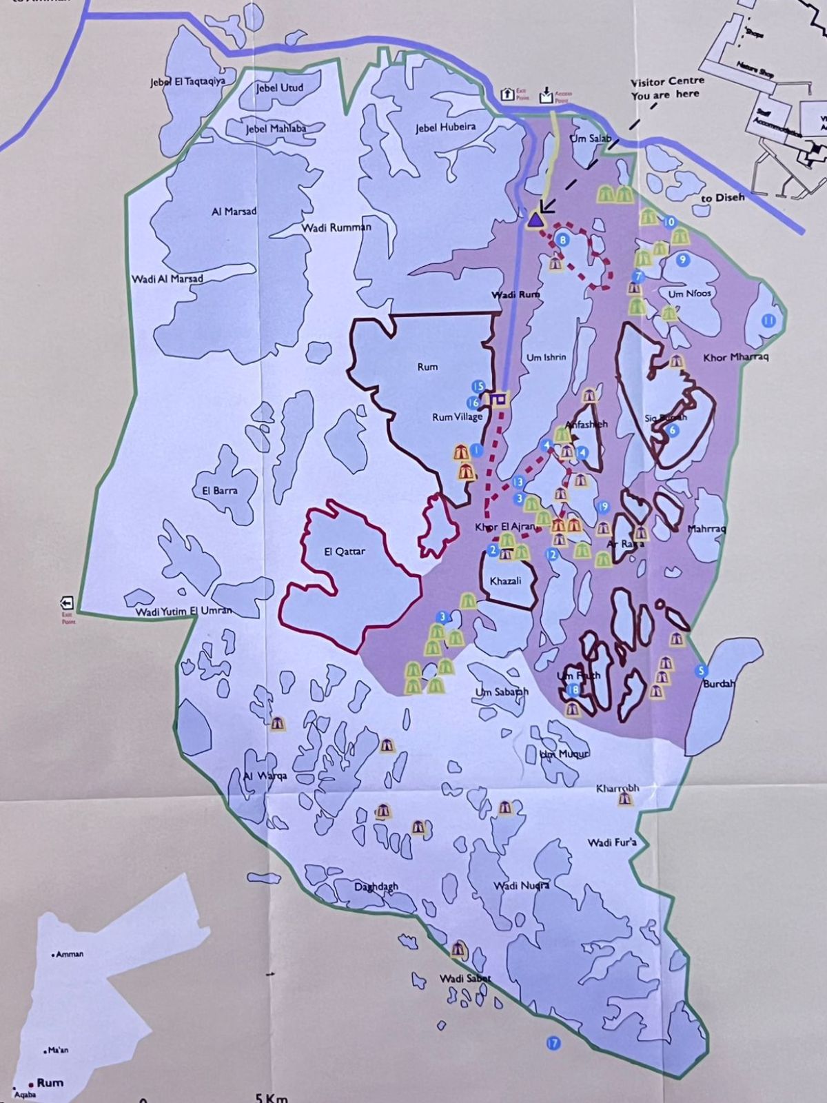
Wadi Rum Map Overview
Use this interactive Wadi Rum map to explore the desert’s top hiking trails, jeep routes, and campsites. Plan your adventure and discover iconic sites with ease. The map highlights landmarks, rock formations, protected areas, and visitor routes, helping travelers choose tours, locate camps, and navigate the Wadi Rum Protected Area confidently. Ideal for first-time visitors and experienced explorers, it offers clear orientation, trip planning support, and practical insight for desert safaris, guided tours, hiking trips, and overnight stays comfortably safely.

Legend Zones
Free Access
Areas open for all visitors without restrictions.
Wilderness Zone
Remote areas with limited access.
Hiking Tracks
Areas open for all visitors without restrictions.
Main Road
Areas open for all visitors without restrictions.
Tourist Road
route for visitors’ vehicles to Wadi Rum Visitor Center
Closed Area
Areas restricted for visitors, hiking or driving.
Climbing Area
Areas designated for climbing activities
Protected Area Boundary
Wadi Rum protected area Borders
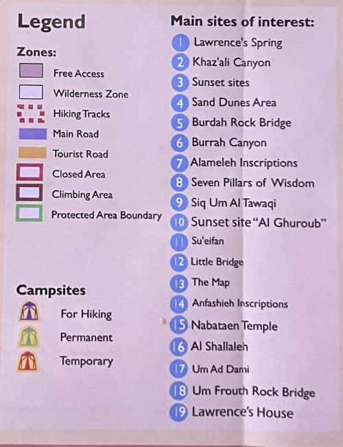
Campsite
Hiking Campsite
Camping place for hikers in Wadi Rum
Permanent Campsite
Established campsite available year-round, with fixed facilities and structures
Temporary Campsite
Campsite set up temporarily, usually for short-term or seasonal use
Main Sites of Interest
1- Lawrence’s Spring – A natural spring in Wadi Rum named after T.E. Lawrence, offering scenic views and a historic stop.
2- Khaz’ali Canyon – A narrow canyon in Wadi Rum featuring ancient inscriptions and a scenic hiking route.
3- Sunset Sites – Popular viewpoints in Wadi Rum to watch breathtaking desert sunsets,
4- Sand Dunes Area – Expansive desert dunes in Wadi Rum, enjoying the desert landscape.
5- Burdah Rock Bridge – A natural sandstone arch in Wadi Rum, popular for hiking.
6- Burdah Canyon – A scenic desert canyon, great for hiking and photos
7. Alameleh Inscriptions – Ancient carvings on rock faces showing camels, hunters,
8. Seven Pillars of Wisdom – A towering rock formation named after T.E. Lawrence’s famous book.
9. Siq Um Al Tawaqi – A narrow canyon with carvings and inscriptions.
10. Sunset Site “Al Ghuroub” – A popular spot to watch the sun set over Wadi Rum desert.
11. Su’eifan – A peaceful desert area surrounded by sandstone mountains,
12. Little Bridge – A small but beautiful natural rock arch with scenic views of Wadi Rum.
13. The Map – A unique rock surface marked with ancient drawings resembling a map.
14. Anfashieh Inscriptions – Well-preserved Nabatean carvings showing camels.
15. Nabataean Temple – The remains of an ancient temple, linking Wadi Rum to Petra’s history.
16. Al Shallaleh – A rocky site with ancient carvings, inscriptions, and traces of water.
17. Um Ad Dami – Wadi Rum’s highest mountain, offering a challenging hike and views over Wadi Rum, Saudi border.
18. Um Frouth Rock Bridge – A famous rock arch that you can climb for panoramic views of the desert.
19. Lawrence’s House – Ruins linked to T.E. Lawrence, once used as a base during the Arab Revolt.
Plan Your Ultimate Wadi Rum Adventure
Discover the magic of Wadi Rum with our interactive Wadi Rum Map, guiding you to the desert’s most breathtaking sites, scenic hiking trails, exciting jeep routes, and well-located campsites. Whether you seek an adrenaline-filled desert adventure, a serene hike, or a thrilling jeep tour, our map ensures you never miss the hidden gems of Wadi Rum. Explore campsites in Wadi Rum, navigate the main roads with ease, and experience unforgettable sunsets and iconic landmarks. Make your journey seamless and memorable by using our map to plan every step of your adventure in the heart of Jordan’s spectacular desert.
Wadi Rum Map – Common Questions
What does the Wadi Rum map include?
The Wadi Rum map includes major landmarks, hiking trails, jeep routes, campsites, and protected areas, helping visitors plan their trip and navigate the desert safely and efficiently.
Are camps marked on the Wadi Rum map?
Some Wadi Rum maps can be downloaded or saved for offline use, which is helpful due to limited mobile signal in many parts of the desert.
Can I use the Wadi Rum map offline?
Yes, the tour is all-inclusive. It includes a packed lunch during the jeep tour, a traditional Zarb dinner (cooked under the sand), and a delicious Bedouin breakfast the next morning. We also provide bottled water and tea throughout the day.
Does the map show jeep tour routes?
Yes, the Wadi Rum map highlights common jeep tour routes used by local guides, allowing visitors to understand tour paths and key sightseeing areas.
s the Wadi Rum map useful for hiking and trekking?
Absolutely. The map is useful for hikers and trekkers, as it shows walking routes, mountain trails, and important landmarks for safe exploration.